


Montat 2

cps46
User
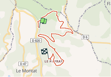

Length
8.7 km

Max alt
278 m

Uphill gradient
291 m
Km-Effort
12.4 km

Min alt
172 m

Downhill gradient
220 m
Boucle
No
Creation date :
2024-02-06 17:05:09.0
Updated on :
2024-02-06 18:33:17.529

FREE GPS app for hiking
 SityTrail
IGN / Geographical institutes
SityTrail Plus
The world is yours!
About
Trail of 8.7 km to be discovered at Occitania, Lot, Le Montat. This trail is proposed by cps46.
Positioning
Country:
France
Region :
Occitania
Department/Province :
Lot
Municipality :
Le Montat
Location:
Unknown
Start:(Dec)
Start:(UTM)
376817 ; 4917127 (31T) N.
Comments